
invites you to participate in a MapRun Navigation Challenge in
West Park, Darlington
|
|
Cleveland Orienteering Klub invites you to participate in a MapRun Navigation Challenge in West Park, Darlington |
|
Follow this link for an introduction to MapRun Navigation Challenges.
Location
West Park is on the west side of the A68 Bishop Auckland Road on the northern edge of Darlington.
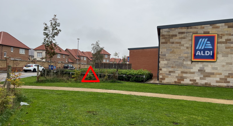
You should be able to park in the Aldi / M&S car park. The postcode is DL2 2GZ, and the What3words reference of the entrance to the car park is ///fade.factories.cried.
Again, click on the link to see a map. You can get directions if you put in your starting location.
Facilities
There are no public toilets nearby. There are customer toilets in Aldi and the White Heifer That Travelled pub.
Running / walking courses
| Long / Hard course | 5.3 km | 55m climb |
| Medium course | 4.0 km | 20m climb |
| Buggy friendly course | 1.3 km | 15m climb |
The Start for these courses is inside the curved section of fence on the grass just east of Innovation Road at the south-west corner of Aldi. The What3words reference is ///being.dishes.hunter.
Click on the link to see a map. You can zoom in (and, optionally, switch to Satellite mode) to see more detail.
In the MapRun6 app, Select Event and look for West Park xxxxx under UK / County Durham / Darlington, where xxxxx is Hard, Medium or Buggy Friendly.
These courses visit West Park and the adjacent urban area. As the courses cross roads, anyone under the age of 16 must be accompanied by an adult.
Running / walking courses that stay in the park
| Short / Easy course | 1.6 km | 45m climb |
| Score course | 20 controls | |
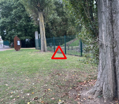
The Start for these courses is beside the fence just outside the north-east entrance to West Park. The What3words reference is ///span.goods.skill.
Unlike the other courses, on the Score course you can visit the control points in any order. Your result is the time it takes you to visit all the controls and then go to the Finish.
In the MapRun6 app, Select Event and look for West Park xxxxx under UK / County Durham / Darlington, where xxxxx is FYW Short or Score.
These courses stay in West Park.
Mountain bike courses
| Hard course | 2.8 km | 75m climb |
| Medium course | 2.5 km | 65m climb |
| Easy course | 1.8 km | 35m climb |
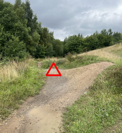
The Start for these courses is at the western end of the banked section in the in the south-east corner of the West Park mountain bike area. The What3words reference is ///twice.puff.rested.
In the MapRun6 app, Select Event and look for West Park xxxxx under UK / County Durham / Darlington, where xxxxxis MTB Hard,MTB Medium or MTB Easy.
These courses stay in West Park.
Paper maps
If you'd prefer to use a paper map rather than the one on your
smartphone (which is going to be quite small and can be tricky
to see in bright sunlight) you can download a PDF copy of the map
from the
Go Orienteering web site and print it off at home.
Note: On the Go Orienteering web site, add the relevant map to
your basket and then go through the checkout process. You
won't be charged anything.
If you don't have a suitable printer, Phill Batts is offering a map printing service.
Results
You can access the results in your MapRun6 app or via the MapRun Console. Open the menu (three horizontal lines at the top left hand corner of the window), select Leader Board and then filter by West Park.
Organiser
Caroline Mackenzie
Planner
Phill Batts
Safety
Please ensure you use a buddy system so that someone knows when you should return.
If you are running after dark or in gloomy conditions, please wear high visibility / reflective clothing; e.g. a high-viz vest, reflective armbands or something similar.
Be aware of underfoot conditions – for example, wet or icy footpaths / pavements / roads – and take appropriate care.
Please be courteous to members of the public in the competition area.
Go to the CLOK home page